For thousands of years, people used seeping surface oil and its relatives, tar and asphalt, for various purposes—medicines, fuels and patching and waterproofing materials. It wasn't until the late 1800's that science was applied to locating underground oil deposits. With demand now at an all time high and deposits diminishing, this century has seen a quantum leap forward in the types of technology used to find oil and natural gas reserves hidden beneath the Earth’s crust and oceans.
According to the United States Geological Survey (USGS) and the Minerals Management Agency (now Bureau of Ocean Energy Management), the world’s remaining estimated oil reserves and natural gas deposits are enough to last the world about 40 years if we continue to use it at the same rate as we do today.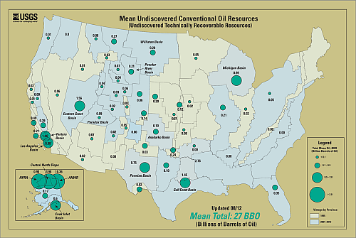
At one time, oil was found mostly in underground reservoirs where it had pooled over millions of years, according to the American Petroleum Institute. After years of exploration and drilling, many of the known large oil reserves have been depleted.
However, that still leaves lots of oil, but stuck in the pores and crevices of sand and shale. In addition, there should be plenty of large oil reserves in out of the way and hard to get to areas such as the ocean, says the World Petroleum Council (WPC), but gone are the days of drilling holes here and there in the hopes of striking oil.
According to the USGS, drilling one hole can cost anywhere from $400,000 to $1,000,000, depending on how deep the hole is and where it is located. Even with the most sophisticated tests and tools we have, there is only a 50% chance of striking oil when we drill. So, at those costs it becomes imperative that the location is pinpointed using the best means available to us, says the Society of Petroleum Engineers (SPE).
There are some basic requirements for oil to form: a source of oil (ancient deposited plant material), a porous and permeable rock (a "reservoir" rock) in which the oil accumulates and an impermeable cap-rock layer to trap the oil.
At the present moment, there are over 25,000 oil explorers roaming six continents in an unremitting search for oil, according to the USGS. These explorers include geologists, geophysicists, paleontologists, mineralogists, stratigraphers, geochemists, hydrologists among other specialists, says Dr. Ione Taylor, Associate Director of Energy and Minerals, from the USGS. She says that they employ the use of gravitational fluctuations, magnetism and seismology to locate hidden oil under the surface of the earth or ocean.
The gravity method makes use of tiny fluctuations in Earth’s gravitational field. Gravimeters are moved across Earth’s surface to measure the downward acceleration of gravity, which can vary by 0.5%. This information is combined with rock information gathered from core samples to look for underground salt structures that might support an oil deposit. Variations in gravity are directly related to variations in density. Salts, which have a very low density and thus a very low gravity, are excellent locations for locating oil, says the SPE.
The magnetic method uses a magnetometer; this device utilizes a free-swinging magnetic needle, which reacts to underground structures. A magnetic survey maps the contours of the underlying granite that form the “crystalline basement.” Granite is nonporous, so finding granite means that you may have found a natural container for oil to pool in. Preliminary surveys are done with the magnetometer mounted on the tail of a plane, but detailed work is done with the instrument mounted on a trailer pulled by a car, according to the SPE.
There are two ways to look for oil seismically, according to the SPE. The passive method uses seismometers, an instrument used to detect and record earthquakes, which are positioned around and monitored for several weeks. Small fluctuations in the seismic readings are used to identify the underlying structure of the Earth. Scientists analyze the seismographs, looking for the rock structures associated with oil formation.
The other method is reflective seismology, using explosives or an electronic thumper on the surface to set up sound waves. Seismometers read these waves, which go deep into the earth and are reflected back when they hit a dense layer of mineral. The reflections are taken at several stations; then the location of the layer is located by mathematics. When these layers are of a particular density and occur at a particular depth, there is a 50% chance that either oil or natural gas will be found, according to the WPC.
All of these methods can be used on the ocean floor after much preparation. The instruments must be water and pressure proofed then dragged along the ocean floor using long tethers and ships. This is a very costly and tedious process.
A new sensor, announced at the 2012 British Science Festival, can measure changes in gravity, even underwater, says Dr. Charles Wang, an astrophysicist, from the University of Aberdeen in Scotland. Lasers have been used to map gravity from space, but do not work well under the ocean. Wang’s technique relies on rubidium.
Wang says that he can use super cooled atomic waves as a precise laser, which can measure gravity better than any previous methods and even works in the oceans. This data will be used to make 3D images of the geologic structures under the ocean floor. Similar technology is already being used on satellites, but the existing technology is large and power-hungry. Wang’s sensor is just centimeters in size and could be used on small submersibles.
“We hope to begin testing the new sensor within the next year,” says Wang.
Recently, optical oceanographer Dr. Chuanmin Hu from the University of South Florida, St. Petersburg, FL, along with colleagues from the National Oceanic and Atmospheric Association (NOAA) and the University of Massachusetts–Dartmouth, found oil bubbling up from the ocean depths while looking at some ocean imagery. Oil decreases the roughness of the ocean and appears as “sun glints” on the satellite photographs.
Hu and his fellow scientists are taking data that was previously discarded and are using it to try to map deepwater oil reserves. While visible, infrared, microwave and radar sensors have all been tried; synthetic aperture radar (SAR) is the most popular and reliable method. SAR, which is mounted on a plane or spacecraft, shoots radio waves between an antenna and the Earth’s surface to gather signal variations, which are used to obtain an image.
| Related stories: Fracking: Appalling Practice or Innovative Development? Growing Green Oil |
“SAR can be very expensive,” says Hu, but “We are using the Moderate Resolution Imaging Spectroradiometer (MODIS) instrument on NASA’s Terra and Aqua satellites. This data is collected daily and provided freely by NASA.” The Terra and Aqua satellites provide remote sensor data so NASA can monitor the state of the earth’s environment and changes in its climate. Olga Hunt

This work is licensed under a Creative Commons Attribution-NonCommercial-NoDerivs 3.0 Unported License





Great article! I can’t wait to share with my students.
:flag it was ok